
TL;DR
An artist has crafted two handmade maps of Hawaii—one depicting the entire 1,500-mile archipelago including minor islands and atolls, and another focusing on the eight main islands. These maps aim to fill a gap in online geographic representations of Hawaii’s smaller landforms.
An artist has produced two detailed handmade maps of Hawaii, one depicting the entire 1,500-mile archipelago including tiny atolls and remote fragments, and another focusing on the eight main islands. This effort aims to address the lack of detailed online maps representing Hawaii’s full geographic complexity, highlighting the archipelago’s smaller landforms.
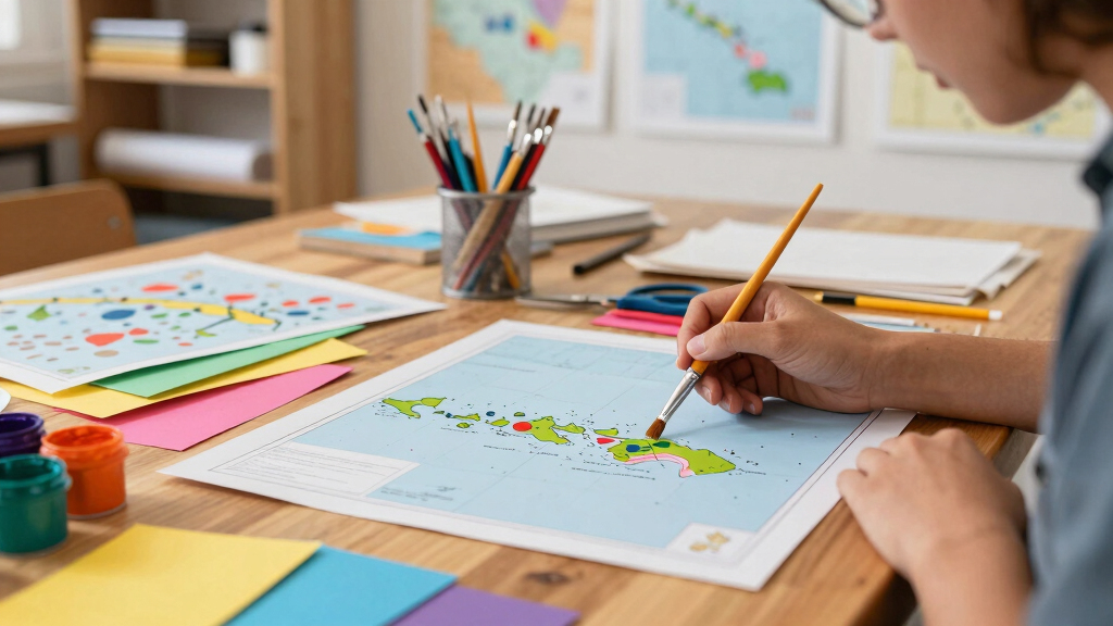
The artist used Adobe Fresco alongside physical watercolor and Copic pens to craft these maps. The full archipelago map covers the entire chain from Hawaiʻi Island to Kure Atoll, including minor islands, atolls, shoals, rocks, and remote fragments scattered across the Northwestern Hawaiian Islands. These small landforms are rarely depicted in existing online maps, which tend to focus on the main islands.
The second map presents a more traditional view of Hawaii, emphasizing the eight main islands—Hawaiʻi Island, Maui, Kahoʻolawe, Lānaʻi, Molokaʻi, Oʻahu, Kauaʻi, and Niʻihau—with greater detail. Both maps combine artistic techniques with digital tools to produce a visual representation that balances accuracy with aesthetic appeal.
The creator stated that the tiny landforms are often overlooked because their geographic size is minimal compared to the main islands, but they are significant for understanding Hawaii’s full geographic scope. The maps are available online, providing a new resource for educators, travelers, and geography enthusiasts interested in Hawaii’s complete land and water geography.
Why It Matters
This development matters because it fills a gap in geographic representation of Hawaii, especially for those interested in the full scope of the archipelago. It offers a more comprehensive visual resource that highlights tiny atolls and fragments often omitted from standard maps. For researchers, educators, and travelers, these maps could enhance understanding of Hawaii’s remote features and environmental diversity. They also demonstrate how art and cartography can intersect to produce detailed, informative representations of complex geographic areas.

Hawaii Map (National Geographic Adventure Map, 3111)
As an affiliate, we earn on qualifying purchases.
As an affiliate, we earn on qualifying purchases.
Background
Hawaii’s geographic complexity is often underrepresented in online maps, which tend to focus on the eight main islands. The full archipelago spans approximately 1,500 miles and includes numerous small atolls, shoals, and rocks, especially in the Northwestern Hawaiian Islands. Prior to this effort, detailed maps of these minor landforms were scarce, often limited to specialized or scientific sources. The artist’s work responds to this gap by creating detailed, hand-crafted maps that blend artistic techniques with geographic accuracy. This effort aligns with a broader interest in geographic literacy and the preservation of Hawaii’s diverse landscape features.
“I wanted to create a map that changed the way people see Hawaii, including all the tiny atolls and fragments that are often overlooked.”
— the artist
“Such detailed maps can enhance understanding of Hawaii’s remote features and support environmental and conservation efforts.”
— a geography expert
HesenDot Natural OAK Wood Framed Hawaiian Archipelago Wall Art,12x16in
Stunning Kauai Scenery: This wall art captures the lush, tropical beauty of Kauai, known as the "Garden Isle"…
As an affiliate, we earn on qualifying purchases.
As an affiliate, we earn on qualifying purchases.
What Remains Unclear
It is not yet clear how widely these maps will be adopted or used by the public, educators, or researchers. The maps are newly created and shared online, but their impact and reception remain to be seen. Additionally, the geographic accuracy of the artistic representations, especially for the tiny atolls, has not been independently verified.
Hawaii Map (National Geographic Adventure Map, 3111)
As an affiliate, we earn on qualifying purchases.
As an affiliate, we earn on qualifying purchases.
What’s Next
The artist plans to continue refining and sharing these maps, potentially creating more detailed versions or digital interactive formats. Further dissemination through geographic or educational platforms could increase their visibility and use. It remains to be seen if other artists or cartographers will produce similar comprehensive maps of Hawaii or other archipelagos.

National Geographic Hawaii Wall Map (34.75 x 22.75 in) (National Geographic Reference Map)
As an affiliate, we earn on qualifying purchases.
As an affiliate, we earn on qualifying purchases.
Key Questions
What inspired the artist to create these maps?
The artist wanted to fill a gap in online geographic representations of Hawaii, especially the tiny atolls and fragments often omitted from standard maps.
Are these maps available for download or purchase?
The maps are currently shared online, but details about their availability for download or purchase have not been specified.
How accurate are the geographic details in these maps?
The maps blend artistic techniques with geographic information, but their precise accuracy, especially for tiny atolls, has not been independently verified.
Will these maps be used for educational or conservation purposes?
Potentially, as they highlight features often overlooked, which could support educational and environmental efforts, though no formal plans have been announced.
Source: Hacker News