TL;DR

Get art and craft supplies delivered free with Prime
- Fast, free delivery on millions of items
- Prime Video, Amazon Music and more included
- Member-only deals all year
A new platform enables users to generate printable paper globes from satellite images. This development combines satellite data with DIY craft, offering an interactive way to explore geography. The project is currently in beta testing and aims to enhance educational engagement.
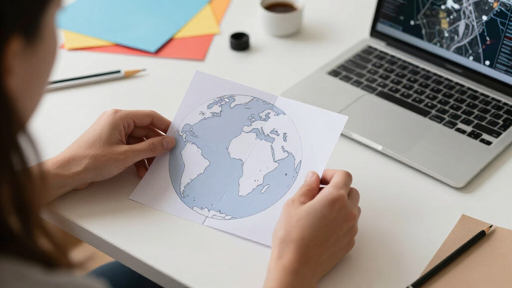
A new online platform has been launched that enables users to turn satellite imagery into printable, foldable paper globes. This innovative tool combines satellite data with a DIY craft approach, offering a hands-on way to explore geographic features and global layouts. The project aims to enhance educational engagement and promote interactive learning about Earth’s geography.
The platform, developed by a tech startup specializing in geographic visualization, allows users to select satellite images of specific regions or entire continents. Once selected, the images are processed into printable templates that users can download and assemble into three-dimensional globes. The process involves converting satellite images into a format suitable for paper folding, with detailed instructions provided.
According to the developers, the tool leverages publicly available satellite data from sources like NASA and ESA, combined with custom algorithms to generate accurate, foldable globe templates. The platform is accessible online and requires no specialized software or technical expertise. It is currently in beta testing, with plans to expand features based on user feedback.
Experts in geographic education have expressed interest in the tool’s potential to make learning about Earth more interactive. The creators emphasize that the globes can be used for classroom demonstrations, personal projects, or as decorative items, bridging digital data with tangible, physical models.
Educational and Engagement Potential of Foldable Satellite Globes
This development matters because it offers an innovative way to engage students and the public with geographic data. By transforming satellite imagery into physical objects, it makes complex geographic information more accessible and tangible. The tool could complement traditional teaching methods, foster curiosity about Earth sciences, and promote hands-on learning experiences.
Furthermore, it demonstrates how satellite data can be repurposed for creative applications beyond conventional mapping, potentially inspiring new educational tools and interactive exhibits. As the platform evolves, it could also support remote learning initiatives and increase awareness of global environmental issues through visual and tactile engagement.
As an affiliate, we earn on qualifying purchases.
From Satellite Data to Creative Learning Tools
The idea of converting satellite images into physical models is part of a broader trend of using digital geographic data for educational and artistic purposes. Traditionally, satellite imagery has been used mainly for scientific analysis, mapping, and navigation. This project shifts the focus toward public engagement and hands-on interaction.
Similar efforts have included 3D printing of geographic features or virtual reality experiences. However, turning satellite images into foldable paper globes is a novel approach that combines digital data with craft, making geographic information more approachable for diverse audiences.
The platform’s development follows increasing interest in interactive learning tools, especially amid growing digital and remote education initiatives. It also builds on open data policies from space agencies, which have made satellite imagery more accessible in recent years.
As an affiliate, we earn on qualifying purchases.
Development Stage and Future Expansion Plans
It is not yet clear how widely the platform will be adopted or how effectively it will be integrated into formal educational settings. The current beta phase limits available features, and user feedback is still being gathered to inform future updates. Additionally, questions remain about the accuracy of the globes for detailed scientific or navigational purposes, as the primary focus is on visual representation and craft.As an affiliate, we earn on qualifying purchases.
Upcoming Features and Broader Accessibility Goals
Developers plan to refine the platform based on initial user feedback, including improving image processing and adding features such as customizable globe sizes and detailed geographic overlays. They also aim to expand the library of satellite images and collaborate with educational institutions to pilot classroom integrations. A public release with more comprehensive tutorials and community sharing options is expected within the next six months.
As an affiliate, we earn on qualifying purchases.
Key Questions
Can I use this tool to create globes of specific regions or countries?
Yes, users can select satellite images of specific regions or countries to generate custom globes, depending on available data and resolution.
Is the platform free to use?
The platform is currently free during its beta testing phase, with plans to introduce premium features or subscriptions later.
How accurate are the satellite images used in the globes?
The images are suitable for visual and educational purposes, but they are not intended for precise scientific measurements or navigation. The focus is on visual representation and craftability.
What materials are needed to assemble the globes?
Users typically need standard printer paper or cardstock, scissors, and glue or tape. Detailed instructions are provided on the platform.
Will this project be available in multiple languages?
Plans are underway to offer multilingual support to reach a broader global audience, but currently, the platform is primarily in English.
Source: hn
Halloween Picks
halloween
As an affiliate, we earn on qualifying purchases.